Winter Harbour To Brooks Peninsula

The Far North Western Corner of Vancouver Island on the Curve of Time
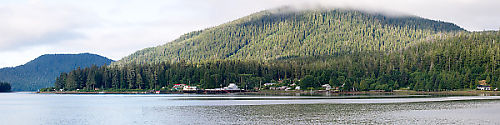
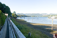
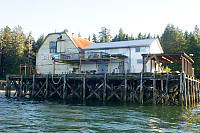
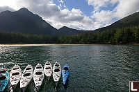
Winter Harbour
Winter Harbour isn't exactly the quickest place
to get to.
From Vancouver, if you catch the 8:30 ferry to Nanaimo (arriving around
10am) you will be in Port Hardy (the largest of the northern
communities) around 2pm and about 2 hours of gravel roads later, you
pull into Winter Harbour.
The town really is focused on the ocean.
The town "center" if
there is such a thing is the large federal dock (red) and the post
office/community center near it's entrance. There is a boardwalk
running from one end of town to the other.
Winter
Harbour seems to be in
flux. You
could imagine a day when the fishing fleet came in every few days with
fish needing packing and the logging industry kept people closer to
larger cut blocks
that this town was at it's perigee. There was a time when there
was two general stores and a restaurant. That said, we couldn't
find parking for a week for less than $25 and the sports fishing
industry seems to be doing really well here - this town isn't going
away any time soon.
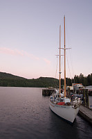
We spent the night tied to the dock - I find I sleep very well on a
boat even if it's rocking very little.
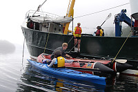
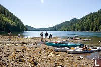
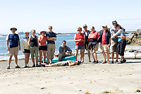
Ahwhichaolto Inlet
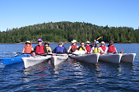
After breakfast, Jan moved the Curve
further up the harbour and anchored behind a large island to give us
some protection from the wind. After getting everyone into the
kayaks (7 kayaks in total) we went over some basics (this is a raft -
if bad things happen - find your way into one) and started down the
bay. We were somewhat a gaggle of wandering boats - some people
explored the islands, others explored the shallows.
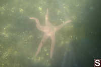
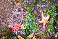
I was particularly happy to seem the shallow
water and
the sea stars. We saw two particularly interesting samples -
first a particularly large pink star and second most of the bat stars
seemed to be blue - not the usual purple/red tones you see.
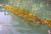
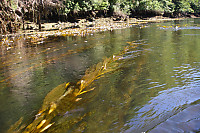
As we moved further down the channel the
flooding tide
carried us fast and deeper down the inlet. At some points
standing waves branched off rock outcroppings in the narrow
channel. The advantage of floats in kelp (and how strong kelp
must be) was made abundantly clear.
We were lucky because Doug (the first mate)
used to
live in this area and he was doing a bit of advanced reconnaissance to
help point out some of the sights. Our first "get out"
destination was a nondescript beach in the bay proper.
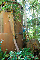
Doug had located an old steam "donkey" - a
steam
engine that was used for for logging from the late 1800's until about
the 1940's. These steam engines had large winches on the front
that could pull logs to transport or pull themselves through the forest.
We stopped at the end of the inlet for lunch
(and another donkey) and
then paddled back. Our round trip distance was roughly 18km - a
lot of paddling for a first day but because we were so well aligned to
the tides, it seemed like much less.
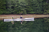
Browning Inlet to Brant Bay
After we got back to the Kayaks, Jan pulled
anchor and we moved into
Browning Inlet. While just around the corner from Winter Harbour,
it was seemed like it could be in the deepest part of the coast -
unspoiled vistas in every direction. Overnight the weather
changed and with a little rain, we got morning fog.
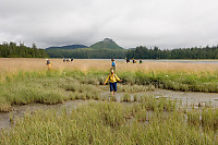
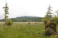
This mornings paddle was comparatively short -
up
Browning Inlet to the
large marshes where we would get our and hike across the peninsula to a
beach (and lunch) on the open Pacific side.
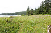
The trip across the marsh was more work than I
thought it would
be. Turns out the marsh is riddled with small streams that drain
in low tides. These small streams cut deep but narrow channels in
the relatively soft soil so a false step could be a twisted
ankle.
Worse yet, the deep grass covers the entire plain so it's none to easy
to spot the holes. Sometimes it was easier to take a lower route,
but
sometimes that lower ground was a mud bowl. That said, you really
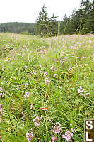
couldn't beat the view.
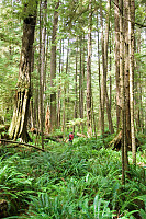
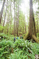
We found the trail at the site of an old
homestead (the apple trees
were all that remained of it) and once we got into the forest, we got
to feeling really small. The trail isn't used much by people
(lots of bear sign through!) so it was a bit of a push to get through
the
underbrush. Once you get past the stunted shore trees you find
yourself among the giant old growth trees.
These massive trees betray photography - there
was no way I could
capture their scale in the forest.
After
a bit of a false path (a
road is being pushed through the peninsula and we turned down the
future road path) we eventually broke through to the other side and the
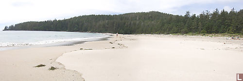
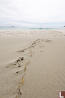
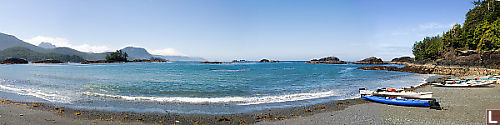
amazing beach.
Seeing this giant white sand beach was almost a
shock - so much of the
coast is rock or trees right to the shore line. We immediately
spread out and explored our own crevices of the beach.
It's amazing how coming back seems so much
easier than getting
there. All too quickly we were back at the boats (thanks
Gérard and William for moving them closer on the high tide) and
eventually we were back at the boat.
Klashish Inlet
On Wednesday it was time for a move.
The weather
wasn't great for open ocean (the waves were enough to make those of us
with the
soft stomaches have a hard time) so I didn't get out much for the
move. Eventually Jan found us a nice sheltered spot and we spent
the afternoon exploring a river by kayak.
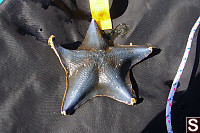
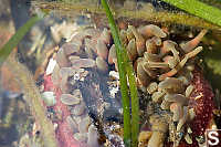
Thursday Morning we went to the shore
for an "intertidal" -
looking at the stuff that grows in the pools and on the
rocks. I've been on a number of intertidal visits in my day
but visits out here are unique because this area is so untouched by man
and being open ocean, often has species that aren't as common in the
more sheltered places along the coast.
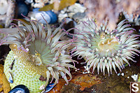
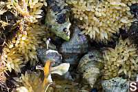
As I said, I've seen a lot. Ochre stars -
seen a thousand of
them. Oh - what's that? A vermilion star (we incorrectly
identified it as a blood star) I haven't seen around Vancouver.
And what's this? Sponge? I can't say I've ever really seen
that!
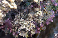
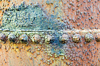
Even the more normal things were special.
We usually get Acorn
barnacle - here they were thatched barnacles. The Dogwinkles
were in egg laying form.
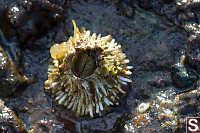
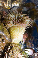
I'm
a big fan of Anemones. Even though Aggregating Green Anemones are
common around Vancouver, here they were dense - occupying places on the
rock that on any other beach would have been stepped on.
Ohh - what's this? A new (to me) species
of Anemone! These
small red anemones were often buried in the course sand, but we found
one semi-open in a tide pool. Again super cool for me.
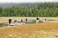
The tide was rising and we needed to get
moving. Our next
destination was the far aside of the bay via an exposed ocean
crossing. The day was pretty calm so the water was more swell
than chop but the swell wasn't kidding around. Once we snuck
around the point and got into the open water, we would loose sight of
kayaks in the troughs between waves. The waves were long enough
that they only rarely came over the deck of the kayaks or caused the
front to drop into water but I wouldn't want to stay out in this water
for a long period of time. The crossing eventually came behind
rocks and we found a sandy beach to land on.
After crossing back and lunch, Jan moved the
boat into the more
sheltered Klaskish Basin.
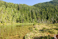
In
the afternoon we decided to go for a combo
kayak
and bush wack - we saw a lake on the topo map and wanted to know if we
could get there. We found a landing place for the kayaks and
tried to penetrate the forest. We started by trying to follow a
creek bed up the slope but (miraculously) stumbled upon a really old
trail
that took us up the ridge. We didn't make it to the lake (our
progress was painfully slow) but we did find a small fresh water
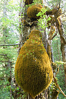
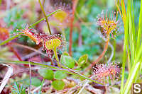
swamp/lake with a bog growing on the side. My favorite bog
species (broccoli shaped shore pines, red moss and sundews) were
present
- I was a happy camper. The bugs were trying hard to change that
so we didn't stay long.
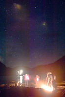
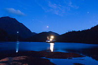
I don't know who thought it up, but going to a
small
subtidal rock for a camp fire was a great idea. We didn't
really get started until after sunset but the crew collected wood and
then set up a fire on a rock that would be below tide before the night
was out. After getting things started, they ferried us over in
the zodiak and we enjoyed the warmth of the fire and the stars overhead
What a great thing to do for the last night of a
trip like this.
Back to Port
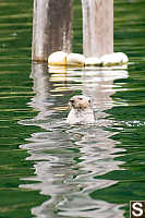
It's
always sad
when a trip like this is
finishing
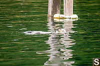
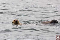
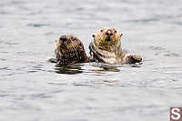
off, but at least we had a highlight at the end. The docks and
bay around Winter Harbour has a healthy Sea Otter population and even
standing on the dock they come pretty close. Between packing a
final coffee, we watched and photographed the otters. A nice end
to a great trip.
Tags: beach(8), kayaking(6), coast(6), BC fauna(5), marine mammal(5), forest(4)
From: John Harvey Photo > John's Overnight Page > Winter Harbour To Brooks Peninsula
I am very interested in the steam donkeys you found. Can you provide any information on the builders, dates or history of these machines? I would like to add them to my list of serviving steam donkeys.
John
John A. Taubeneck
Tuesday, April 17th, 2007 at 13:26:51
Beautiful. Will be cruising and fishing this area this summer.
Joe Granacher
Monday, April 30th, 2007 at 16:28:05
I just wanted to say thank you so much for posting these pics of Winter Harbour! I used to live there as a child and I've been dreaming of going back my whole life. Seeing these pictures has brought back so many fond memories.
Brittney
Thursday, March 27th, 2008 at 16:06:16
I used to live in Quatsino Sound as a young person so was very interested to view your images. Thank you for bringing back good memories.
Andrew Schreiber
Thursday, April 3rd, 2008 at 19:35:33
Great pictures, except I would have liked some more information on your locations as you traveled, and your method - where and how did you find the boat that chartered you? Did you rent it? Some friends and I are planning a trip to brooks peninsula. How many hours would you estimate it would take by boat? I would really appreciate any information you might have, thank you!
Kerry
Tuesday, July 1st, 2008 at 11:52:48
Thanks for the pictures of Winter Harbour, I lived there from 1958 to 1960. I retuned in 1998 love the place but it is a long way from Australia.
Philip Crooks
Sunday, September 28th, 2008 at 20:44:34
If it's any help, I did my trip through Due West Charters:
http://www.duewestcharter.bc.ca/
The trip from Winter Harbour to almost Brooks Peninsula. It took us about 3 days to get to Brooks, but the actual travel time was about 6 hours. (The Curve of Time isn't very fast, but that is kind of the point). Due West Charters kinds of picks a part of the west coast and then books trips in that area, but if you contact Jon, you might be able to convince him to do a trip there (especially if you can fill his boat).
There is a fishing company (or two) in town in Winter harbour. For example:
http://www.winterharbour.ca/services.htm
Will do "Adventure boat tours". I'd bet they can get you there. That said, I'm not sure what you will do when you get "there". Kayaking without support in that part of the world can be very hard (On a nice day the sea is rough and there aren't many nice days). There are no trails (that I know of) to walk and camp. I think there was an article in the Summer 2006 issue of Beautiful British Columbia magazine that might also be helpful if you are planning on doing something self propelled.
John
John, Thank you again for posting the photos of your trip in the Winter Harbour area. The photos of Browning Inlet, the marsh, the trail and Grant Bay (Open Bay to the "oldtimers") was like going on a W. H. community picnic in the 1940's The access to this wonderful beach was either by anchoring the salmon trollers off the beach and rowing ashore, in calmer weather or by Browning Inlet and the marsh. My family collected many glass balls. In your photo of the marsh are two old growth filled stumps. My father and grandfather told me these and many lother trees were felled by the First Nations people of the area pre European contact and iron tools. The trees were felled by placing hot coals in a circle to cut through the trunk. There is one of these culturally modified trees at the camping ground in W.H. Lots of history in this whole area. Thanks again, Evie
Evie Beaveridge (North)
Saturday, January 10th, 2009 at 15:02:51
These are great pictures. I Grew up in Winter Harbour and lived there from age 5 in 1956, through to the end of 1998. Our family commercial fished during summer months and logged for W.D. Moore Logging during the winter months. There was no better place on earth, I believe to grow up, it was one adventure after another. There was no roads access for many years and the only way in, or out was by boat or sea planes (beavers - cessnas) out of Port Hardy airport.
Harry Paulsen
Saturday, January 9th, 2010 at 20:53:18
Thanks for posting these pictures. I plan on visiting Winter Harbour this summer. I want to do some fishing and enjoy the serenity of the lovely area.
Chris Powell
Wednesday, January 19th, 2011 at 14:28:51
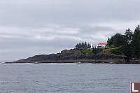
Hello :
I lived on the light house shown from 1935 untill 1944. Very nice photo layout, brought back many memories. Wondering if there is a tour outfit that would run to Quatsino, Winter Harbour and Kains Island. Departing from possibly Coal Harbour, or Port Alice. Cheers.
Roy E. Carver
Thursday, February 24th, 2011 at 09:50:53
Winter Harbour looks like a great place for a new adventure. What was the accommodations like?
thanks again
Ed
Ed Lapins
Saturday, November 12th, 2011 at 08:06:49
We stayed on a ship that was moored at the dock - the
Curve of Time. There is a B&B in Winter Harbour and I believe there is a fishing resort in town as well.
Last Modified Tuesday, June 9th, 2009 at 01:13:28 Edit
Copyright and Contact Information.